
We arrived at Cloud Nine RV Park just east of Hot Springs Arkansas on Sunday, April 2. Elvis and I have been exploring the green spaces of Hot Springs while Shawn works.
OK. So a lot of what we do isn’t considered hiking by purists, but if it involves any sort of incline/decline or off-pavement excursion, I’m counting it. To me, a hike is anything that gets me close to nature and raises my heart rate.
East Mountain – Hot Springs National Park
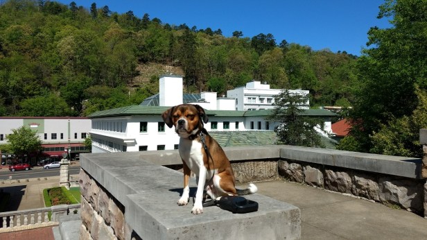
On Tuesday, we drove into downtown Hot Springs to take a hike up East Mountain. Trails are well marked, and maps are available at the Visitor’s Center downtown. I keep our stocked “doggy bag” — a waist pack from eBay — in the car, and just fill up the water bottle before heading out.
The trail access for East Mountain is right behind the Visitor’s Center, which itself used to be one of the turn-of-the-century glamorous bathhouses and is still open for tours. Elvis is squinting along the promenade, a lovely mile-long brick street just behind the bathhouses which line the main historic downtown. Trails leave from the promenade and are well marked.
 I foolishly took the Peak Trail to start — half a mile, all incline. Idiot. I had to stop for breath a half dozen times in the half mile. My face was red from the 50th step onwards. Oh well. Elvis had no trouble, I think he has more muscle in his little back legs than I do. Bless his heart.
(If you’re from the South you know what I mean with that comment.)
Here I am, all sweaty, red, and gasping for air. Keep scrolling. Quickly.
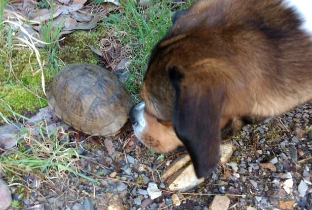 The big highlight of the day was the turtle that came tumbling down the (short) slope and landed along the edge of the path. My best guess is some sort of box turtle; he did not want to stick his limbs out for better identification. I think it’s the first time Elvis has sniffed a reptile; he was very intent!
The volunteer that came along behind us gently lifted him and set him on the downslope, a few feet off the path. I hope that’s the way he was headed when he took his spill!

Water runoff channels were frequent along the trails. They varied in form and material, all designed to channel a deluge away from the paths and reduce erosion. We walked over many a trickling stream on this spring day. Also along the trails we spotted many deep holes, ranging from 1-3 feet in diameter, which showed where trees had toppled.
The geology of the area is quite fascinating – if you’re a geek like me and want to read more, you can download the Hot Springs National Park Geologic Resources Inventory Report.
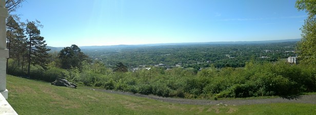
Near the peak of the mountain, there’s a shady pavilion below the Hot Springs Mountain Tower where we took a short rest (and a panoramic snapshot) before heading back down the mountain to the car. The Tower itself rises an additional 200+ feet, and provides a 360-degree view for many miles. I’m saving that for the weekend when Shawn and I can take the Juke along the switchback road and take the elevator to the top.
Back at the car, I rewarded myself for the hard climb by purchasing Whoopie Pies (Almond Joy & Snickerdoodle – Shawn’s favorite) from the Sweet Stuff Bakery. Ohmygoodness, they were delicious! Looking forward to visiting their sister shop, the Fat Botton Girls Cupcakery, this weekend. Maybe I’ll remember to take pics next time.
Hot Springs Greenway Trail
This morning we took it easy. After giving Elvis 15 minutes of fetch at the off-leash Bark Park, we headed across the Hot Springs River and took to the trail. On a brisk Thursday morning (53 degrees at the start), it was pleasantly empty. We walked the sections marked in red, out and back.
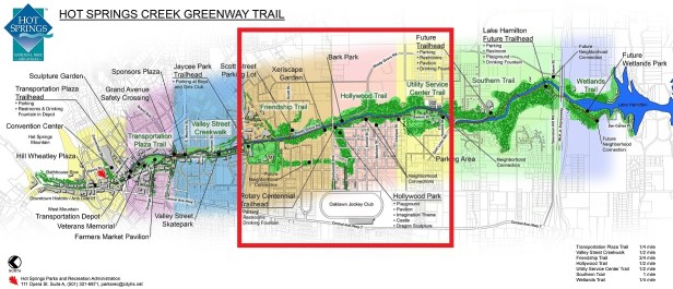
Like many others, this trail is a work in progress. About 3.5 miles have been completed, and more are planned.
We walked along a broad, paved path alongside the river, under the power pole easement. I love the sound of running water and would easily drive from any local area to walk here.
The Garland County Master Gardener Association maintains some of the plantings. I also passed many wildflowers, very few of which were familiar to me. I didn’t bother with trying to take images of the flowers, as my smartphone wouldn’t render them clearly.

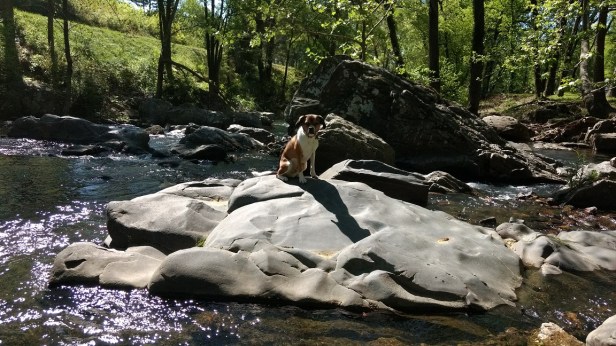
Can you spot the dog? He’s doing so well with the sit-stay!

The trail (and the adjacent road) go under this railroad trestle. I couldn’t tell if it was still in use.

I’m wondering if this last image is a strangler fig? The entire (large) tree was enveloped in vines, reaching 50 feet into the air and a spread nearly the same.
These sit-stay photo shoots are good training practice for when we travel to more exotic locations and I have a better camera and more photographic know-how. We’re working up to longer times, more distance from mom, and more types of terrain. Unfortunately, Elvis doesn’t know how to say “cheese.”
What are your favorite trails?
Side note: Using a quick Google search turns up this listing for the trail on traillink.com. I don’t know why the index says that this trail is in Memphis Tennessee! I used to have the traillink app on my old phone – need to download and install it to the new(er) one I guess. I’d forgotten about this excellent resource.

My favorite trail is from the table to the fridge. I can handle that one very well. those others? not for me. Good dog.
LOL.
Loved your post. It reminds me of your nature walk posts back in Hines Park. Elvis is a very good model!
Thanks Victoria! I thought this might be a little mundane, so I’m glad you enjoyed it.
The scenery looks amazing. We’ll have to visit the area sometime.
Love this hiking with Elvis and am totally with you on your definition of what a hike is! Yup, absolutely right on. Love the shots of the river and boulders and Elvis sitting beautifully in the one. Lucky dog!
Peta
I think we are just following you guys around the country. We are heading to Hot Springs next week! I was just reading up on it as we are on the road today. Looks like there’s a lot to see and do, though unfortunately, we won’t be there nearly long enough to see everything. 😦 Anyway, we’re looking forward to doing some hiking while there so this is good info to have.
That’s terrific 🙂 We are here through 4/15, so I’d love to meet up once you get here! My hubby is a HUGE GSD lover, so of course we have to meet Dixie, and you can show me how you got that cool custom Google map to display on your blog.
Sounds like a plan! I’ll ping you on Monday when we are en route. Maybe we can grab dinner Tuesday or Wednesday night…
Great! I forgot to ask: where are you booked?
Elvis is way too cute! I love the sit-stay photos. Would love to take Lexie when I hike, but she starts to lose power at the 1/2 mile mark, has a slew of drool hangees (she’s a mastiff), and plops down until she’s darn good and ready to move again (forcing her only brings forth stomach contents). 🙂 She’s a great lay-down-and-sleep dog, but not a good let’s-go-get-active dog. Elvis looks like an excellent hiking buddy!
LOL, I’m telling Lexie what you said! 😉
Elvis is a good hiker. He has way more stamina than me, and even off leash he’s pretty good about staying within 40 feet or so (but I still want to work on that!). And if he’s ever injured, I can carry him (a certain distance).
Love your definition of a hike–perfect! This place is beautiful–Arkansas is one of those states we never seem to make it to. One of these days during one of our road trips we’re going to make it a point to go through there!
I knew absolutely nothing of Arkansas. We chose Hot Springs because it was roughly halfway between Austin TX and Crossville TN. It’s really lovely here. We’ll explore more of Arkansas in future years!